

On August 28, Beijing released the 2023 edition of its standard map, sparking outcry throughout South and Southeast Asia.
India, Malaysia and the Philippines all filed diplomatic protests over what they said was China’s inclusion of their territory or maritime areas within China’s borders.
Chinese Foreign Ministry spokesperson Wang Wenbin said the uproar over the release of the map was much ado about nothing.
“[Releasing the map] is a routine practice in China’s exercise of sovereignty in accordance with the law. We hope relevant sides can stay objective and calm, and refrain from over-interpreting the issue.”
That is misleading.
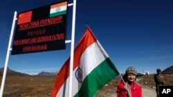
The map shows two large Himalayan border areas disputed by India and China as Chinese territory. They are Aksai Chin — which is the easternmost part of the Kashmir region and mostly controlled by China — and Arunachal Pradesh — a state in northeastern India that New Delhi largely controls but Beijing claims is part of Tibet.
China seized control of Tibet after invading the region in 1950, and annexed it in 1951.
The United States recognizes Arunachal Pradesh as a part of India.
India’s Foreign Ministry said it “lodged a strong protest through diplomatic channels with the Chinese side” over the map, adding that “such steps by the Chinese side only complicate the resolution of the boundary question.”
India and China have been locked in a decades-long border dispute along the so-called Line of Actual Control, a roughly 3,500-kilometer notional demarcation line between Indian-controlled territory and Chinese-controlled territory that was drawn following a 1962 war.
After a brief eruption of violence in 2020, resulting in the first reported deaths along the Line of Actual Control since 1975, tensions have periodically flared. Another non-fatal skirmish occurred in December 2022.
In recent years, China has built settlements in territory claimed by India in the region, including in Arunachal Pradesh, a 2021 Pentagon report to the U.S. Congress said.
Less murky in the eyes of international law are the territorial claims that China demarcated on the map usiing 10 dashes, covering most of the South China Sea and Taiwan.
The dashes encompass maritime areas falling within the Exclusive Economic Zones (EEZs) of Vietnam, the Philippines, Malaysia, Brunei and Indonesia.
The U.N. Convention on the Law of the Sea, which China ratified in 1996, recognizes an EEZ as the 370-kilometer stretch of sea from the coast of a state.
In 2009, China laid claim to most of the South China Sea and its land features.
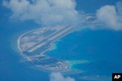
The Philippines challenged China’s claims at the International Permanent Court of Arbitration, and in 2016, the court largely found in the Philippines’ favor. China has dismissed that ruling and continued aggressive actions against the Philippines.
On August 5, the China Coast Guard used water cannons to stop Filipino vessels from delivering supplies to a ship moored off the Second Thomas Shoal in the Spratly Islands, which fall within the Philippines' EEZ.

It was not the first time China has used force to stop Philippines ships from approaching the shoal.
The mapped claims also include parts of Malaysia's EEZ near Sarawak and Sabah, which are Malaysian states on the Island of Borneo, and Brunei, which is embedded in Sarawak and shares a 161-kilometer coastline along the South China Sea.
Malaysia, like the Philippines, filed a diplomatic protest over China’s map.
Indonesia’s Foreign Minister Retno Marsudi said territorial lines and claims must be consistent with the U.N. Convention on the Law of the Sea.
Vietnam said it “resolutely opposes all China’s claims in the South China Sea based on the dotted line.”
Taiwan, a self-governing island which the communist-ruled mainland views as a breakaway province, also denied Beijing’s claims.
“[Taiwan is] absolutely not a part of the People's Republic of China,” said Taiwan Foreign Ministry spokesperson Jeff Liu.
"No matter how the Chinese government twists its position on Taiwan's sovereignty, it cannot change the objective fact of our country's existence," he told a press briefing.
The map also appears to show China with complete control over Bolshoy Ussuriysky Island, located at the confluence of the Amur and the Ussuri rivers on the border between Russia’s Far East and northeastern China.
In 2008, China and Russia agreed to divide the island after a long-standing dispute.
The Russian news outlet RBC said it had sent a request to the Russian Foreign Ministry for comment regarding the map, which had not been answered at the time of publication.
Beijng and Russia announced a “no limits” partnership weeks before Russia invaded Ukraine, and China’s support is viewed as critical to that war effort.
Mark Kat, a professor at George Mason University‘s Schar School of Policy and Government, told Newsweek magazine that Russian President Vladimir Putin "is not in a position to loudly complain” about the map, given Russia’s economic dependence on China following Western sanctions over Moscow's war in Ukraine.
China’s map claims follow the BRICS (Brazil, Russia, India, China and South Africa) Summit held in Johannesburg, South Africa, last month. Beijing hopes to use BRICS as a counterweight against the West.
It also comes ahead of the Group of 20 summit in New Delhi, India, scheduled for September 9 -10, which Chinese leader Xi Jinping is expected to attend, and the Association of Southeast Asian Nations (ASEAN) Summit in Jakarta, Indonesia, set for September 5-7.